Background of the Philadelphia & Lancaster Turnpike
Early Roads used the Philadelphia Courthouse located at Second and Market as their Eastern terminus. Milestones on the Philadelphia and Lancaster Turnpike originated from the West bank of the Schuylkill River. There was also no permanent bridge over the river until 1805, which according to one account burned in 1806. Today this would be the market Street or 30th Street bridge. Measuring the mileage from the West side of the river made more sense. This made turnpike mileage 2 to 3 miles less than other starting points in Philadelphia. An example of this is in Downingtown where the 30 milestone sat near the Halfway House. In the same area of that stone is a 33 milestone from a 1771 road. Now part of the reason for that is because the mileage was figured using a less direct road, but part of it is probably a more Western starting point. The Halfway House hosted a future president, James Buchanan, and the Continental Congress on the run from the British in 1777. Sachse said that after the permanent bridge was completed stages left from the corner of 8th and Market in Philadelphia
*Above banner images of flags were taken at the Christmas Day
Reenactment of General Washington and the American Armies crossing
of the Delaware River into New Jersey. The victories that followed kept hope
alive for the Americans in the Revolution. Links for both sides of the River
http://www.state.nj.us/dep/parksandforests/parks/washcros.html
http://www.nps.gov/nr/travel/delaware/was.htm
http://www.state.nj.us/dep/parksandforests/parks/docs/washington_crossing_brochure.pdf
http://www.stepintohistory.com/states/pa/Washington_Crossing.htm
The question is what happened to these early turnpike milestones? The Turnpike was completed in 1795
and in 2009 (214 years later) about a third of the 62 stones are still known to exist. Some of the stones have
been replaced with 8 foot tall plinths. Others have simply been replaced such as the 19 milestone. In his book on the Lincoln Highway
Michael Wallis sums it up this way. "Through the years the stones have been removed by road crews, farmers or souvenir hunters.
They have been found in front of suburban homes, near Villanova college, behind a guardrail, by a gas station and in a parking lot."
An unsung hero in the battle to save the milestones was Susan Frazer and the Colonial Dames she worked with. According to John Fahis in his book Old Roads Out of Philadelphia she and her group found and relocated as many of the markers as possible in 1907. Some of the stones were found leaning against barns, one was being used as a doorstep. She even dug one up by figuring out where it should be. She placed them at their original distance using a simple but ingenious system. She would place a white ribbon on her wheel spoke, early cars had wooden spokes and then count the number of revolutions, 470 revolutions equaled one mile, stop and search or dig.
In regard to inns, taverns and other places of interest along the early turnpike - the places I've attempted to document were active when the turnpike was at its highpoint between 1795 and the 1830's when the railroad began to surpass turnpike mileage. Some places were active before the turnpike took off but would have still been something a traveler might see along the way. An example of this would be Joel Ferree's Gun Shop which made rifles for the continental army during the revolution. Many of the inns and taverns went on to serve other functions and I've attempted to document that as well. The Sign of the Stage in Paradise for example became a seminary for girls before the Civil War.
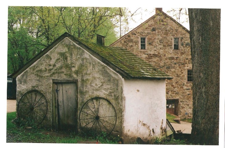
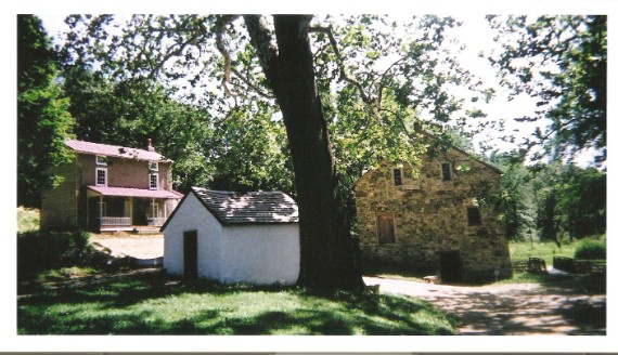
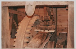
The four pictures in the body of this page were taken at The
Mill at Anselma, Chester County, PA. Use
the links to learn more about the mill and its
wonderful history or to plan a visit.
http://www.myspace.com/themillatanselma
http://sites.google.com/site/anselmamarket/
http://www.anselmamill.org/mill.htm